The Mission-Critical Resource Center

Subscribe to Newsletter

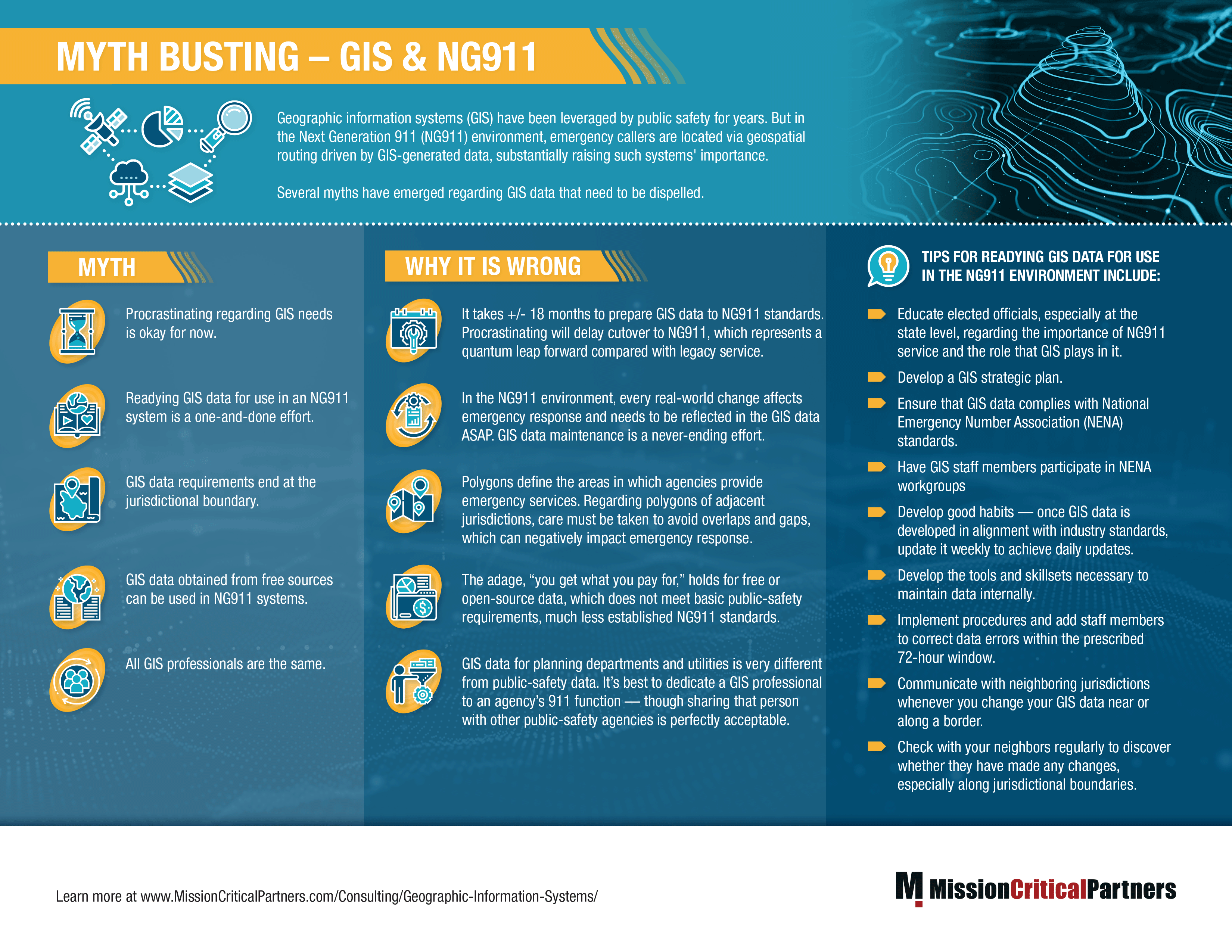
Infographic: Myth Busting – GIS & NG911

Geographic information systems (GIS) have been leveraged by public safety for years. But in the Next Generation 911 (NG911) environment, emergency callers are located via geospatial routing driven by GIS-generated data, substantially raising such systems' importance, and this infographic dispels the several myths that have emerged regarding GIS data.

MCP Helps Region 13 Better Understand Its GIS Environment

In Summary:

  • GIS-generated geospatial data will be used in the NG911 environment to ensure that emergency calls are routed to the appropriate emergency communications center (ECC) to dispatch the appropriate emergency response
  • Today, Region 13 Task Force, a collaborative effort of 14 counties in southwestern Pennsylvania, plus the city of Pittsburgh, manages a emergency services Internet Protocol (IP) network (ESInet). To continue their efforts towards a regionwide approach, the task force wanted the ability to share data between the counties
  • Having the ability to access data regionally will go a long way toward eliminating gaps and overlaps along jurisdictional boundaries that negatively impact the abilty to dispatch the appropriate response to an emergency incident, amongst other benefits

MCP Helps Carroll County Move Closer to NG911 by Supporting Its GIS Efforts

In Summary:

  • A county in Maryland needed to develop a plan to create and maintain GIS data and continue the migration to Next Generation 911 after a key GIS professional retired.
  • GIS plays an essential role in the transition from legacy 911 service to NG911 service, which will rely on GIS-generated geospatial data to locate callers, route calls correctly, and dispatch the appropriate emegency response.
  • The county partnered with Mission Critical Partners to assume the duties of the PSAP's departed GIS professional and provide a Model for Advancing Public Safety (MAPS) assessment that would act as a roadmap for implementing NG911 service within its jurisdiction.

Whitepaper: Don’t Take Shortcuts When Developing NG911 GIS Data

Geographic information system (GIS) data is a foundational component in the migration to, and continuing operation of, Next Generation 911 (NG911) systems. But developing local GIS data so that it aligns with NG911 standards is a laborious and time-consuming process that can take months or years to complete.